TDEM Survey in Baluchistan
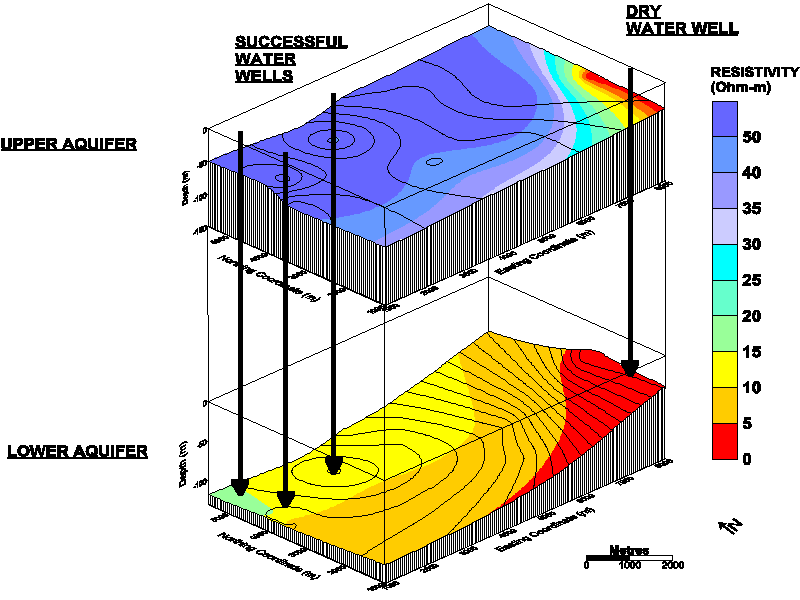
This groundwater exploration project covered an area of 150 square kilometres of sandy desert in Baluchistan, Pakistan. No maps or hydrogeological information were available prior to the arrival of the field crew. A 300 metre deep dry well had been drilled in the centre of the area, but all drill cuttings had been discarded.
A TDEM survey was designed to obtain information on subsurface resistivities from the near surface to depths of 500 metres. All navigation was accomplished by GPS, and maps were produced digitally from GPS positions. A full interpretation was completed in the field, and three water wells were pegged prior to the demobilization of the field crew. All three water wells were successful.
The initial project area of 150 square kilometres was reduced to 40 square kilometres following a reconnaissance survey of the area involving the sampling of existing and abandoned hand-dug wells and interviewing the local bedoine population via an interpreter. All areas where the groundwater in existing wells was rich in TOC and H2S were not surveyed.
The TDEM soundings in the study area displayed a distinctive apparent resistivity curve that could be modelled by a simple four layer model. This was interpreted in conjunction with the conceptual hydrogeological model.
-
Layer 1 - Unsaturated zone above the water table : 100 - 200 Ohm-m
- Layer 2 - Upper aquifer, the best potential drill target : 40 - 80 Ohm-m
- Layer 3 - Lower aquifer, with a higher clay content and/or a lower quality groundwater : 10 - 15 Ohm-m
- Layer 4 - Clay or silty clay, impermeable and/or saline groundwater : 2 - 5 Ohm-m